Wednesday, September 30, 2015

Update on Hurricane Joaquin


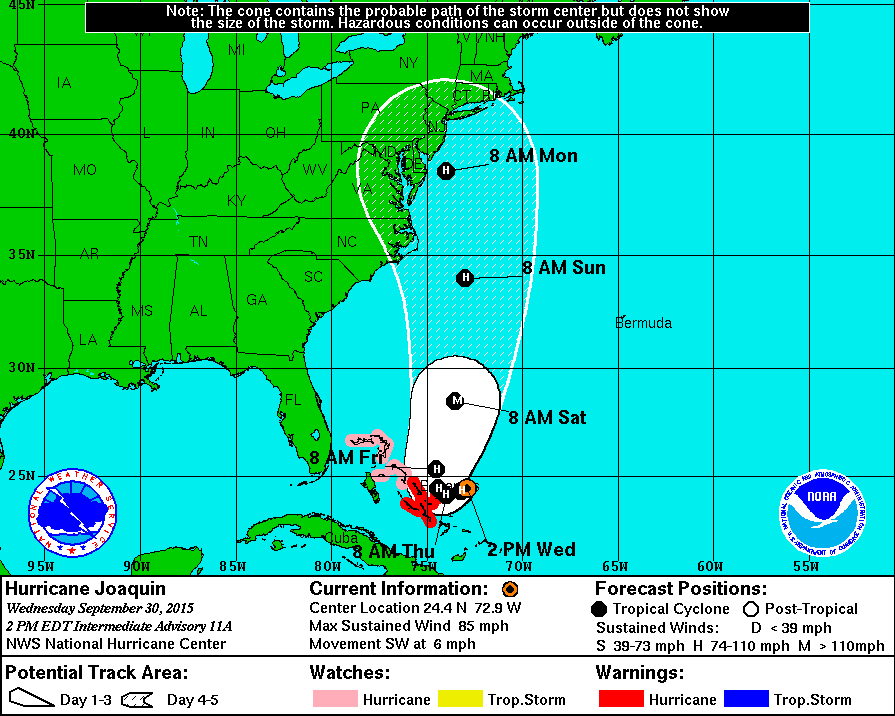
Hurricane Joaquin forecast track as of 2PM, Sep 30, 2015 (map courtesy of the NHC)
Tropical Depression 11 developed into Tropical Storm Joaquin yesterday and into Hurricane Joaquin today. As mentioned a few days ago when the depression was just forming, the potential exists for the storm to eventually have an impact here (or at least somewhere on the east coast). The current projection shows the storm continuing to develop and intensify and slowly begin to move in a northerly direction, possibly reaching Category 3 strength. The storm is over historically warm waters at this point and the main item that has kept it from intensifying even quicker has been continued wind shear.  The real question is where it goes after turning north. It could curve more northwestward and impact areas to our south or continue north and impact western mass directly or be curved out to sea. The latest guidance puts the track more west than east with an impact somewhere along the east coast. There various forecast models are having a tough time figuring out a high confidence track for the storm as there are many variables that could interact with the storm and change the actual track, especially out beyond a few days. Regardless of the final path we are likely to at least get some heavy rain and wind from the storm.  I will update over the coming days. 

Link to some additional related information regarding the storm and related birds can be found at a Birdcast post here:  http://birdcast.info/forecast/special-alert-upper-midwest-and-northeast-tropical-storm-joaquin/

A link to tropical system related birds in western Massachusetts as well as various of useful links related to tropical weather can be found at this link from an earlier post:
http://quabbinbirdingandbeyond.blogspot.com/2015/02/a-look-at-tropical-storm-related.html

Below is the projected storm location and strength for the next five days.

FORECAST POSITIONS AND MAX WINDS

INIT  30/1500Z 24.7N  72.6W   70 KT  80 MPH
 12H  01/0000Z 24.3N  73.2W   80 KT  90 MPH
 24H  01/1200Z 24.1N  74.0W   85 KT 100 MPH
 36H  02/0000Z 24.4N  74.4W   90 KT 105 MPH
 48H  02/1200Z 25.3N  74.5W   95 KT 110 MPH
 72H  03/1200Z 28.5N  73.5W  100 KT 115 MPH
 96H  04/1200Z 34.0N  73.0W   90 KT 105 MPH
120H  05/1200Z 38.5N  74.0W   75 KT  85 MPH


Last night and today we have dealt with heavy rain associated with a variety of weather features and the rains produced 5"+ of rain leading to some local flooding.  Beyond a few species of waterfowl likely being forced down I have not seen nor heard of anything way out of the ordinary associated with the heavy rain of yesterday and today.

No comments:

Post a Comment